This specific page is the requests page for the Map Workshop. Anyone can make a request for a map to be created or improved. The standard format for making a request is shown below, along with general advice, and should be followed.
Make a request
Show manual procedures
Use the following template when making a new request, replacing the examples with your image(s) and request(s):
<gallery>
 IMAGENAME.EXT|Description of image
 IMAGE#TWO.EXT|2nd image (If there is one)
 ETCETCETC.EXT|Don't request too many at once, though
</gallery>

;Request:
: Details of your request go here… --~~~~
;Graphist opinion(s):
SpBotarchives all sections tagged with {{Section resolved|1=~~~~}} after 7 days and sections whose most recent comment is older than 185 days. For the archive overview, see /Archive. The latest archive is located at /Archive/2024.
I'm not certain what the best source map would be, but I'd appreciate a Commons-compatible version of the map of Figure 6 (page 37) of this PDF (also accessible via this link) for the draft currently at en:User:Ljleppan/Polttoainehankinta. In addition to the Areas of Responsibility, it would be good to show the locations of en:Helsinki, en:Porkkala and a few of the larger cities (Perhaps en:Turku, en:Vaasa, en:Oulu, en:Rovaniemi and en:Ivalo if possible without sacrificing legibility?).
One of the discussions you linked mentions the colours are a poor choice for colour-blind users, may be worth considering that too before editing 130 files. Chipmunkdavis (talk) 02:07, 26 June 2024 (UTC)[reply]
Since international borders are shown in this map, the border of Tibet, which is not independent, needs to be removed. Oirattas (talk) 13:38, 23 May 2024 (UTC)[reply]
There are changes and corrections that should be made to this map. Firstly, Morocco and Syria should be in grey, as there is no cited information on the above linked Wikipedia page to say suicide is illegal in either country (as the map currently claims). Secondly, Chile and Cuba should be in green as suicide is cited as legal in both, while assisted is suicide illegal. Helper201 (talk) 01:35, 29 February 2024 (UTC)[reply]
Graphist opinion(s)
Update request for the Indonesia Ethnic Groups Map
Is there anyone here who would like to make revisions, additions, and also make an English version of this map? I already have a list of things that need to be revised and updated, but I will mention these things in stages considering the length of the list I have. Note: I already have the name labels on this map in English and Indonesian, so you don't need to translate them anymore, just write them on the map. --Ibrahim Muizzuddin (talk) 08:19, 3 March 2024 (UTC)[reply]
Hi @Timeshifter. I am not sure to directly help here but I would like to share some thoughts related to your request:
I found that for many users editing a "simple" text file such as svg is not so obvious. For this reason I think it will be nice to have a graphical interface to do so. For this reason I started working on a tool like this one. The interface is not very good but it has some nice features to help editing maps. I can upload more maps if needed.
Few years ago I made a proposal to seaparate the css files from the svg. In fact, we have a lot of maps that represent the same countries or regions but need different colours. I though that it will be good to have one svg with the geographica representation and a separate file for the colours. There was some intresting discussion on this but not accepted.
I think we will need to have some deeper discussion on the format for this kind of svg maps. I personally belive that it will be good to have some classes and features in the svg that can help automatic detection of specific elements or machine use for editing.
Ikonact. cmglee is the main creator of the map templates. Maybe he can tell us what he thinks of your maps.
I have a question. Is there a way to paste in a list of states and values into your maps. To make maps with the data on the maps. That is what is possible with cmglee maps. It is very easy to do. Just need the list. A good set of colors is already in the map. Those colors can be changed.
cmglee can probably adapt this data map template method to other countries and their subnational areas (states, provinces, etc.). --Timeshifter (talk) 17:53, 8 April 2024 (UTC)[reply]
That's a useful tool, @Ikonact: Though I prefer scripting, I can see other editors preferring a GUI. Will it have a way to save a draft and resume editing, or to load someone else's map to make changes?
I didn't see your proposal in 2017, and would very much welcome having SVG files referencing or transcluding other files. I've been using a hack using systemLanguage so that a single SVG can generate different thumbnails, e.g. for each tower's article:
@Cmglee: I remember, I have seen your svg with the towers and I find it a good idea. I find it a twist as the purpose of the systemLanguage is different but I agree it is a good work around. The main issue is that this will not work for multiple elements - if you wish to highlight several states on a map for example. I will be glad if we can propose something that make sense. I have to admit I am playing solo for the moment :-) Ikonact (talk) 13:33, 16 April 2024 (UTC)[reply]
This is a valid SVG file edited in Inkscape but saved as plain SVG. When I look at this file in Inkscape or in a web browser, the arrowheads are pointing in the correct direction. When viewed on Wikimedia, the arrowheads all point to the right. Any help is gratefully received for getting the arrows to render properly on Wikimedia. --MartinPoulter (talk) 16:18, 11 April 2024 (UTC)[reply]
I've updated this to a version without arrowheads. The previous version had the arrowhead problem: I still welcome advice on how I can put arrows into diagrams in Inkscape and have the arrowheads render properly on Wikimedia. MartinPoulter (talk) 15:29, 12 April 2024 (UTC)[reply]
These maps of the European Union (and likely more! this I found in the same category) still have the United Kingdom, despite it having leaving years ago. --Juwan (talk) 17:00, 6 May 2024 (UTC)[reply]
I would like for the original image of 2017 (uploaded by Minnekon) to be restored, but with en:Truso in the correct place (namely on the right bank of the Vistula, as Artur Andrzej tried to move it in 2023). The issue with the 2023 correction is that the overall quality of the image has degraded. I tried to fix the problem myself by editing the 2017 original and moving Truso to the right bank in Microsoft Paint, but I got much the same result as Artur Andrzej in 2023. It probably has something to do with the .gif format that I do not understand. If anyone can make a higher-quality image in any other kind of format (like .svg), perhaps even with a different underlying map altogether, but showing much the same information, that would also be appreciated; I'm not tied to this image in particular. --Nederlandse Leeuw (talk) 07:58, 12 May 2024 (UTC)[reply]
Example of a map for the "State of Somaliland" (from the administrative point of view of the Somali authorities), which is not sufficiently country-centric.
Could someone use the first map as a reference to put an overlay of the highlighted red area into a vector map, like the second map in the gallery (preferably zoomed in more on Germany, like in the first map)? -- Colohisto (talk) 01:36, 20 May 2024 (UTC)[reply]
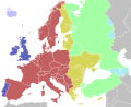
Article(s):w:en:Freedom of panorama (to replace Commons-slanted EU-FoP map in the article, which is supposed to be neutral (and not excessively favor Wikimedian perspective) per w:en:WP:NEUTRAL.)
Request
Change the color for both Belarus and Ukraine to yellow from red, as both have non-commercial FoP (yellow is for non-commercial FoP countries).
Change also Sweden to light green as there is indeed FoP only for buildings, but no commercial FoP for monuments and public art.
Add Kosovo, as dark green (yes FoP since October 2023).
Add Andorra, Monaco, San Marino, and the Vatican City - as red.
@Cmglee (note: the ping didn't work for some reason, but this page is on my watchlist as of now)
It is based on the Commons perspective (in which non-commercial uses are treated as "not OK"). But since that article is in English Wikipedia, it should be neutral and should not favor on Wikimedia side. JWilz12345(Talk|Contrib's.)08:02, 10 June 2024 (UTC)[reply]
Hi! Please update and vectorize this outdated raster map file. The C and F lines have been permanently discontinued in 2021 and 2020, respectively, so both need to be removed from this map. Thank you! --OrdinaryScarlett (talk) 02:04, 26 May 2024 (UTC)[reply]
Hi, I was wondering if anyone could put together a map of Africa overlayed with the maximum extent of some major kingdoms and empires. I can provide a list of kingdoms and empires that'll give a fair representation of the continent's history, although many of them might overlap so maybe have the fill transparent? At the moment we use File:African-civilizations-map-pre-colonial.svg which has extraordinary bias towards west and north Africa, and gets some of the territory wrong such as for Aksum and Hausa (which was never a kingdom). The map used would ideally include Arabia, the Levant, and some of Iberia as these were territories which were covered. The style I'm happy to leave to you, although I'd like it to be colourful. --Alexanderkowal (talk) 12:35, 12 June 2024 (UTC)[reply]
Thanks for making this request! To the graphist: also important to include are Madagascar’s pre-colonial unified kingdoms. Zanahary (talk) 21:09, 12 June 2024 (UTC)[reply]
Could someone make an svg map of the borders of the Second Polish Republic as of 1929 superimposed on modern European borders? Two versions would be best, one blank and one with locations and names of important cities that either was previously inside Poland (like Lviv and Vilnius) and cities that became a part of Poland after World War II (like Wrocław)? --Colohisto (talk) 05:45, 4 July 2024 (UTC)[reply]
Can someone please update this map to have France and Greece shaded? Both countries are cited in the Europe section of the linked Wikipedia article as allowing self-ID. Helper201 (talk) 22:22, 12 July 2024 (UTC)[reply]
starting October 27, Ukraine will no longer observe summer time (sources in article above). it means that Ukraine will be coloured yellow instead of ochre. technicalities: Russian-occupied regions follow a different separate time zone (UTC+03:00) all year round (fact-check?). see file page for more information. --Juwan (talk) 14:26, 16 July 2024 (UTC)[reply]
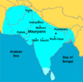
Really just the Ifat Sultanate and Ethiopia is needed, but if you could include Ajuran and Warsangali in the corner that'd be grand. There are images on wikicommons of all of these that can be copied. --Kowal2701 (talk) 19:34, 21 July 2024 (UTC)[reply]
Graphist opinion(s)
Map(s) of proposed LaGuardia Airport subway extensions
One or two maps showing both proposed extensions of the BMT Astoria Line to LaGuardia Airport, as illustrated on pages 17 and 18 of this 2022 PDF from the Port Authority. This can be one image showing both alignments or separate images for each. The current Astoria Line should be in this yellow (#fccc0a, PMS 116) while the proposed alignments can be a lighter shade of yellow. --Qzekrom (talk) 01:01, 30 July 2024 (UTC)[reply]
 Map workshop
 A potential base map
.svg/220px-Finnish_Defense_Forces_Areas_of_Responsibility_(early_1950s).svg.png)
.svg)

 Raster map file #1
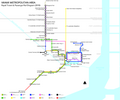 Raster map file #2 (also needs to be updated)
 Raster map file #3


 This is originally created by Maxxl2 , I just corrected some location.But sadly it saved into PNG.
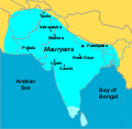 The svg that the edit request is for

 Suicide legislation world map
 Map of ethnic groups in Indonesia in Russian


 Map of the Ottoman Empire in 1590
,_administrative_divisions_-_de_-_colored_(EU_labeled).svg)
,_administrative_divisions_-_de_-_colored.svg)
,_administrative_divisions_-_ISO3166_-_colored_(EU_labeled).svg)
,_administrative_divisions_-_ISO3166_-_colored.svg)
,_administrative_divisions_-_Nmbrs_-_colored_(EU_labeled).svg)
,_administrative_divisions_-_Nmbrs_-_colored.svg)
,_administrative_divisions_-_de_-_colored_(marker).svg)
,_administrative_divisions_-_de_-_colored_(multizoom).svg)
,_administrative_divisions_-_Nmbrs_-_colored_(marker).svg)
,_administrative_divisions_-_Nmbrs_-_colored_(multizoom).svg)
.svg)

.svg)

.svg)

 2023 image (Truso corrected, but quality degraded)
.svg/120px-Somaliland_in_its_region_(less_biased).svg.png) Example of a map for the "State of Somaliland" (from the administrative point of view of the Somali authorities), which is not sufficiently country-centric.
Example of a map for the "State of Somaliland" (from the administrative point of view of the Somali authorities), which is not sufficiently country-centric..svg)
 Image to vectorize
 Vector map that can be used


 Outdated raster map file
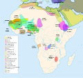 Map of major African kingdoms and empires throughout history
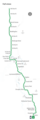
 Missing station
 Raster map
 Time zone map of Greater Europe

 Lesser Antilles location map
.svg)
.svg)